





 asdar.id menyediakan Member Premium Download untuk download file tanpa embel-embel iklan dan halaman, apa lagi harus menunggu timer yang begitu lama. Dengan berlangganan Member Premium Download, semua file dapat didownload dengan singkat langsung menuju ke sumbernya!, klik DISINI untuk DAFTAR atau DISINI untuk LOGIN :-) Jika ada pertanyaan silahkan hubungi Admin DISINI. Untuk cara download file Member Free Download, bisa membaca Tutorial Download yang ada dibawah Timer (halaman Safelink) saat menekan tombol download.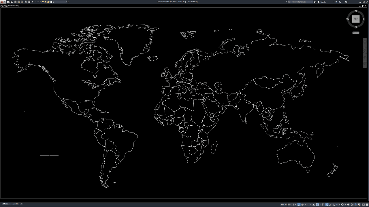
World map drawings are useful references for architectural presentations, civil engineering documents, educational materials, geographic visualization, international project reports, logistics planning, and many other design applications. Having a clean and editable world map in CAD format allows designers to integrate geographic graphics directly into technical drawings without recreating continental outlines manually.
In this article, we share a reference for World Map DWG AutoCAD that can be useful for architects, civil engineers, urban planners, GIS specialists, surveyors, CAD technicians, graphic designers, students, consultants, and other professionals. The drawing can be used as a practical base for presentations, location diagrams, global project maps, planning documents, and CAD-based geographic illustrations.
What Is a World Map?
A world map is a graphical representation of the Earth’s surface showing continents, countries, oceans, and other geographic elements on a flat plane. Depending on the level of detail, a world map may contain only continental outlines or include national boundaries, coastlines, islands, labels, coordinates, and additional geographic information.
In architectural and engineering documentation, world maps are often used to communicate project locations, regional connections, international operations, transportation networks, or geographic context.
A simplified world map is particularly useful when the purpose is presentation rather than detailed geographic analysis.
Benefits of Using a World Map in AutoCAD
Using a CAD-based world map provides greater flexibility than inserting an ordinary JPG or PNG image.
The geometry can be edited individually, which means designers can simplify areas, emphasize selected regions, remove unnecessary lines, or add additional graphical information.
A DWG world map can also maintain sharper line quality when plotted at different scales.
This is particularly useful for technical reports, presentation boards, engineering diagrams, and architectural drawings that require consistent linework.
Download World Map DWG AutoCAD
Proper World Map DWG AutoCAD drawings are useful for accurately presenting continental outlines, national boundaries, coastlines, and global geographic relationships in architectural presentations, engineering reports, planning documents, educational materials, and international project diagrams. Architects, civil engineers, urban planners, GIS specialists, consultants, and CAD technicians can use this type of drawing to integrate a clean world map directly into technical or presentation-based CAD documents.
Detailed drawings such as world map outlines, continent boundaries, country borders, coastline geometry, island outlines, and editable vector linework help designers and planners create clear geographic presentations without redrawing the map manually. As shown in the drawing, the CAD file presents a complete world map with the outlines of North America, South America, Europe, Africa, Asia, Australia, and surrounding islands, together with internal country boundaries represented as editable CAD linework.
Incomplete or poorly prepared World Map DWG AutoCAD drawings may result in distorted geographic proportions, missing boundaries, inconsistent coastlines, or difficulties when highlighting specific regions for presentations. Accurate and well-organized CAD geometry is therefore important when the map is used for architectural portfolios, international project locations, engineering reports, logistics diagrams, or educational purposes.
Detailed AutoCAD DWG files also allow users to review and modify country outlines, continent boundaries, lineweights, layers, scale, hatches, project markers, and annotations according to specific presentation requirements. The drawing shown provides a practical reference for world map CAD drafting, geographic presentation, country boundary mapping, international project visualization, architectural diagrams, and engineering documentation.
For those of you who prefer a simpler and faster download experience on asdar.id, I also provide a Premium Member Download service that allows direct access to the original file. This way, you will not be disturbed by excessive advertisements or multiple redirect pages during the download process. If you are interested, please register HERE. Please download the World Map DWG AutoCAD file below:
World Map DWG AutoCAD
| Google Drive | DOWNLOAD[423.61KB] |
| Mediafire | DOWNLOAD[423.61KB] |
Rar password: www.asdar.id
Important Note: If you encounter a problem where the WinRAR file cannot be extracted or appears corrupted, the solution is to update the WinRAR application on your computer to the latest version. Download the latest version of WinRAR here.
If you would like to copy this article, please include the original source because I have seen some blogs repost the content without providing proper credit. Otherwise, please rewrite it using your own words. Respect and appreciate the work and effort of others.
World Map DWG AutoCAD drawings provide a flexible and practical reference for anyone who needs editable geographic graphics inside a CAD environment.
The drawing can be used for architectural presentations, engineering reports, planning studies, corporate portfolios, international project maps, and educational materials. Because DWG geometry can be edited, scaled, layered, and annotated, users can easily customize the world map for different design and presentation requirements.
For professional GIS or surveying applications, geographic accuracy should always be verified separately, but for CAD-based visualization and presentation work, an editable world map can significantly simplify the drafting process.